


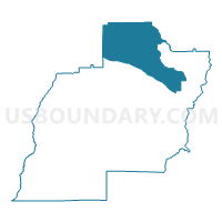
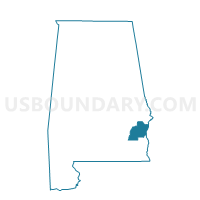
Springhill Volunteer Fire Department, Barbour County, Alabama
About
Outline

Summary
| Unique Area Identifier | 521217 |
| Name | Springhill Volunteer Fire Department |
| County | Barbour County |
| State | Alabama |
| Area (square miles) | 121.37 |
| Land Area (square miles) | 121.29 |
| Water Area (square miles) | 0.09 |
| % of Land Area | 99.93 |
| % of Water Area | 0.07 |
| Latitude of the Internal Point | 32.04717740 |
| Longtitude of the Internal Point | -85.31281640 |
Maps

Graphs
Select a template below for downloading or customizing gragh for Springhill Volunteer Fire Department, Barbour County, Alabama


Neighbors
Neighoring Voting District (by Name) Neighboring Voting District on the Map
- Bevill Center/Chatthoochee Cts Com Ctr/Eufaula Com Ctr/Eufaula WB/Fellowship BC/Sanford AG, Barbour County, AL
- Clayton Courthouse, Barbour County, AL
- Cowikee Volunteer Fire Department, Barbour County, AL
- Hurtsboro Fire Dept Voting District, Russell County, AL
- Midway, Bullock County, AL
- Pittsview Fire Dept, Russell County, AL
Top 10 Neighboring County Subdivision (by Population) Neighboring County Subdivision on the Map
- Eufaula CCD, Barbour County, AL (13,785)
- Clayton CCD, Barbour County, AL (4,264)
- Cottonton-Seale CCD, Russell County, AL (3,990)
- Hurtsboro CCD, Russell County, AL (1,873)
- Midway CCD, Bullock County, AL (1,434)
Top 10 Neighboring Place (by Population) Neighboring Place on the Map
Top 10 Neighboring Unified School District (by Population) Neighboring Unified School District on the Map
- Russell County School District, AL (24,278)
- Barbour County School District, AL (14,320)
- Eufaula City School District, AL (13,137)
- Bullock County School District, AL (10,914)
Top 10 Neighboring State Legislative District Lower Chamber (by Population) Neighboring State Legislative District Lower Chamber on the Map
Top 10 Neighboring State Legislative District Upper Chamber (by Population) Neighboring State Legislative District Upper Chamber on the Map
Top 10 Neighboring 111th Congressional District (by Population) Neighboring 111th Congressional District on the Map
Top 10 Neighboring Census Tract (by Population) Neighboring Census Tract on the Map
- Census Tract 9502, Barbour County, AL (4,264)
- Census Tract 312, Russell County, AL (3,990)
- Census Tract 9501, Barbour County, AL (3,321)
- Census Tract 311, Russell County, AL (1,873)
- Census Tract 9507, Barbour County, AL (1,727)
- Census Tract 9521, Bullock County, AL (1,434)